
Monday, December 30, 2013
Congratulations to NAVY!
Coulda, Woulda, Shoulda

My Micmac stripper canoe, stern to the shore during a
cold winter's morning.
I jotted these points down after reading the story some time ago. A nurse had worked for many years with the terminally ill and infirm. During the times when family weren’t at the bedside, she got time to share her patients’ lives, thoughts, and regrets. Looking back over their lives, knowing they had only days or perhaps hours to live, these were their final thoughts on what they would have changed, in descending order, if they could have done it over again. The greatest gifts coming out of their lives may be that they can help the still living avoid the same mistakes, if we but listen and take heed. Copy them and tape them over your desk or work station.
1. I wish I had lived a life true to myself, not the life others expected of me.
2. I wish I hadn’t worked so hard.
3. I wish I’d had the courage to express my true feelings.
4. I wish I had stayed in touch with my friends.
5. I wish that I had allowed myself to be happier.
Some thoughts from Jerry Vandiver and the Morrall's.
http://www.youtube.com/watch?v=e-x7GT3rFVw
Saturday, December 28, 2013
Canton Lake: Going to the Dogs
I took an afternoon ride to check out Canton Lake to see if it is filling any at all. It isn’t. It’s still down 78% of its conservation water level, and looks pretty much like the shots taken at Lake Altus-Lugert. Maybe it’s just me, but when the lakes and waterways look forlorn, their appearance connects directly into my mood. I’ve lived on, around, and been connected with waters for so much of my life, we’re inseparable.
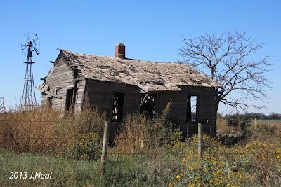 The local scenery doesn’t help much. Yet another old homestead sits long forgotten. The incessant Oklahoma wind has blown out all the aged blades from the windmill, the bleaching sun has destroyed the roof shingles, weeds have recovered all that was their’s originally, and the house itself has taken a list in want of something to lean on.

 The only signs of life are the prairie dogs that are out scampering about. As you get near, they stand on the lip of their burrow and bark an alarm to all their neighbors. Some become quite animated. So much effort is put into the barks that they lunge up and down as their front legs thrust outward. They look like little basketball players making two-handed foul shots with each bark. The ones in this tape are more sedate than that, but I think you’ll find it interesting.
http://www.youtube.com/watch?v=jcB5kySUxWA


Chubby prairie dogs in a constant search for food.

Ever vigilant.
http://www.youtube.com/watch?v=jcB5kySUxWA
Tuesday, December 24, 2013
Another Taste of Christmas

We found the holiday decorations done early when we visited Branson, Mo.
This lamp and wreath struck me as being right out of Currier and Ives. They
were located at the boat landing of the Showboat Branson Belle, which we
visited for a dinner and show. I'll have more on that at another time, but since
that will put us after the holidays, I figured I should pull these out now.

Monday, December 23, 2013

Saturday, December 21, 2013
Happy Winter Solstice

Credit: off-grid info
During the shoulder seasons, the dilema is always when to stop for the night in order to have enough light to get camp established, make dinner, and roll into the sack before we find ourselves stumbling about in total darkness save for the beam of our headlamp. The answer is in the sunset. Here’s how you do it without an app.
With your arm outstretched, fold the thumb into the palm, and hold your palm facing you and the fingers horizontal. With your little finger resting on the horizon, when the lower limb (bottom) of the sun touches your index finger, you have one hour until sunset. As the lower limb appears to peak between the fingers, you lose 15-minutes with each finger it passes. When the sun touches the horizon, and you have sunset and light will now begin to fade, but you still have another hour before complete darkness. If you plan for several possible campsites for the night, you can extend the day, feeling confident in which stop you can reach and still have enough light for camp duties.
Wednesday, December 18, 2013
Reading the River
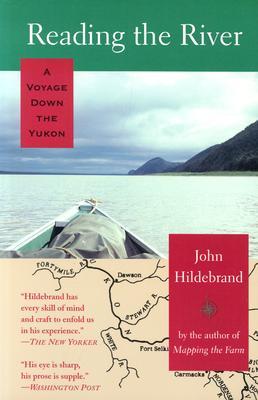
Jacket illus. credit: goodreads.com
John Hildebrand is an exceptional writer. His reviewers call him a latter-day Thoreau, and the best adventure writer since Jack London. He uses this skill to take you on a three-month, 2,000 mile trip by canoe down the Yukon River, and when you reach the last page, you’ll likely share my sense of emotional collapse over the trip being done. He not only writes so you can nearly smell the smoke and hear the snapping and crackling of your shared driftwood campfire, but he’ll take you to every village and fish camp along the river where he’ll introduce you to the Alaskan frontiersmen willing to share their own stories. There are survivors of the days of the Alaskan gold rush, Eskimos, Athabascan Indians, wilderness homesteaders, subsistence hunter/trapper/fishermen, dogsled mushers, missionaries, and Russian family members still reflecting the days when Russia provided the greatest influence in the area. He’ll share his salmon catch, or take you along as he helps pull salmon nets, have you sing your way through the wilderness so the grizzlies know you’re there, sleep in tents, cabins, and the homes of ‘river angels.’
John and his wife had dreamed of homesteading in the Alaskan wilderness. He cut and dragged the logs, trimmed and shaped them, notched the ends and stacked them, and stuffed the chinks between the logs, and roofed it until he had completed a log cabin. He cut and split wood to heat the cabin with a wood-burning metal stove, and through the seasons grew or hunted for all their food. After all of this, his wife’s biggest complaint was that there was nothing to do, and she found she was no longer enamored of their dream. Finally, after losing a child shortly after birth, she went back south. John followed, hoping to save their marriage, but she finally divorced him, and of course took everything he had except the cabin she wanted nothing to do with.
After a decade, the author returned to Alaska, but found he just couldn’t go back to the cabin, so he started his trip down the Yukon. The title, Reading the River, is misleading. The story is nothing about reading a river to find one’s way through the river‘s eddies, rapids, and shoals, but more about navigating through life’s hazards and obstructions. In the process, he gives you an experience you’ve probably never had before. When the canoe trip ends, in a final twist, we find him…., well, you need to follow along to see where the trail leads. Your only regret after reading this book will be that there’s not another 300 pages or so.
Monday, December 16, 2013
Ugly Hedgehogs

Fox looking into camera.
credit:googleimages
http://www.uglyhedgehog.com/user_page.jsp?upnum=977
Saturday, December 14, 2013
Twelve In a Row, Consecutively
Navy wins 34 to 7. Twelve rivalry wins in a row consecutively. Yeah, I know that’s redundant, but it bears saying twice. Plus, Navy wins the Commander-in-Chief’s Trophy for the year. Congratulations to them all. Unfortunately, Army kept shooting themselves in the foot. We have to feel for them, especially the seniors.
Regardless of which team it is, or which academy, in the end they are all on the same team supporting our nation. Those that attend the service academies are our nation’s brightest and best. They struggle through the toughest application processes of any schools in the nation to get an appointment, perform at higher standards throughout their academy training, and maintain the highest standards of service, sacrifice, and leadership throughout their careers. We owe each of them a slap on the back, a tip of the hat, and our thanks and appreciation for all they do. In the end, we all win---everyday.
Here are a few views from the Naval Academy. If you travel through Maryland, a visit to the Academy in Annapolis is a must-see.

Bancroft Hall, largest dormitory in the world.

Memorial Hall

U.S. Naval Academy Chapel

The crypt of John Paul Jones beneath the chapel.
Friday, December 13, 2013
GO NAVY!

Thursday, December 12, 2013
Lake Altus-Lugert
Lake Altus-Lugert appears on P.49, grid D-7 of the DeLorme Atlas, and P. 113 of the “Lakes of Oklahoma” guide by the Oklahoma Water Resources Board. The lake covers 6,260 acres, and has a 49 mile shoreline.
 The town of Lugert, also created out of the 1901 land-grab of the Kiowa, Comanche, and Apache lands, now sits at the bottom of the lake. It was destroyed by a 1912 tornado that demolished 41 of the town’s 42 businesses. Lugert was then a town of 300 people. The foundations of many of their homes and businesses can be seen when the lake water levels are low. A historical marker commemorating the town and Frank Lugert, who had filed for the land to build the town on, stands at the head of the lake’s main boat ramp. Frank Lugert’s general store and post office was the sole business left standing in town after the tornado.
 The town of Altus initiated the move for a dam in 1927. The construction was made possible by the Rivers and Harbors Act of 1938. Dam construction was halted in 1941 because of World War II, resumed in 1944, and completed in 1947 with a dam 110 feet high and 1,104 feet long.
 Lake Altus-Lugert was a recreational mecca for Southwest Oklahoma. Between the mountains and the lake, it was a natural place for numerous attractions like a state park, resort and lodge, golf course, nature center, performing arts complex and outdoor amphitheater, swimming beaches, and RV and tent camping. With the absence of the lake, the area’s economy is taking a substantial hit.
 With the serious and ongoing drought in the region, I had called ahead to ascertain if water levels were good for paddling the lake. The lady I spoke with, obviously a representative of the local Chamber of Commerce, assured me the lake had plenty of water, was beautiful, and everything was as it should be. I had serious reservations about all that, but desperation to get on the water will make one go to unusual extremes, or at least me. When I drove over the last rise that overlooks the lake, it felt like my heart had just dropped into my boots. It was so shocking, I hit the brakes and pulled off the road to make sure I believed what I was seeing.
 At the parking lot above the boat ramps, what should be a floating walkway goes out some distance between pillars of rock. The walkway is supposed to be just about level with the parking lot, but I walked down and down. As I got close to the rocks, the grey surfaces I was seeing obviously became the dead and bleached plant life that had been at the lake’s bottom. The line between the gray covered rocks and the natural red surfaces rose above my head as I stood on the float at the end of the walkway. As I talked with a photographer about how sad it all looked, I scanned the span between the rock under the float and the old waterline well above our heads, I said, “Ya know, that’s got to be 30-feet.” When I got home, I searched the Corps of Engineers gauge to find that the water was indeed down 29.97 feet. It now is at 30.00 feet. That leaves 13% of the lakes capacity, which sounds like it is better than nothing, but that little bit of water that’s left is basically useless. It’s too low to reach the aqueducts for the farmers’ cotton crops, it is both too low and too salty for drinking water, and the salt, lack of oxygen, and resulting golden algae bloom have killed off the fish. Lake Altus Lugert was known as the home of striped bass and walleye that made for state-record catches. It is now a dead lake.
State officials say Southwest Oklahoma is experiencing the worst drought since 1895. We may not wish to be so bold as to seek heavy rain for 40 days and 40 nights, but to fix either the drought or fill the lakes, it would take at least a couple years of rains so much above normal that we’d become thoroughly sick and tired of rain.

Buddy sits atop the Ram, all dressed up and no place to
go. Looking at the rock formation off-shore, note the line
between grey and red rock. That should be the lake's
waterline. The white rectangle at center is the roof of the
fishing float that should be at least level with the top of the rocks.

The floating walkway should be roughly level
with the parking lot.

Between the float's height and my height of eye, the camera
is about 15-ft. off the lake bottom, and is still looking up at
what should be the water level.

This was my first sight of the lake. I'm standing on the
riprap that borders the lake and protects the road from
erosion, which is no longer an issue. The line of bushes
between me and the remaining water is the foundation
of a normally submerged building. Everything between
the rocks in the foreground and the tree-line at the base
of the mountains should be lake water.

Except for the vegetation on the bank in the foreground
and some peaks in the distance, you should be seeing
nothing here but deep water and fishermen angling for
large striped bass and walleye, all now dead.
State officials say Southwest Oklahoma is experiencing the worst drought since 1895. We may not wish to be so bold as to seek heavy rain for 40 days and 40 nights, but to fix either the drought or fill the lakes, it would take at least a couple years of rains so much above normal that we’d become thoroughly sick and tired of rain.
Wednesday, December 11, 2013
Two-Year Mississippi Sojourn
http://www.youtube.com/watch?v=M9rhfG4U5ZA
Above is the link for John F. Sullivan's photographs from his two-year trip down the Mississippi River. With thanks to John for sharing, enjoy the sights and music.
Above is the link for John F. Sullivan's photographs from his two-year trip down the Mississippi River. With thanks to John for sharing, enjoy the sights and music.
Monday, December 9, 2013
Nahanni: River of Gold, River of Dreams

Illus. Credit: abebooks.com
Neil Hartling knows the Nahanni, since he’s a river guide on the river, and has been since 1984. The book is a full-color coffee table style book with many amazing photographs of the river’s scenery. In between the pictures, Hartling weaves a narrative about the geological history of the area, the history of legend, and the history of the early explorers, miners, trappers, and adventurers that traveled the river, some successfully, and some who have left their bones there. Whether planning a trip to the North, or just enjoying the love of water and nature that we all share, it’s a book worth seeking out.
Credit: Google Images
Thursday, December 5, 2013
Janet Moreland Reaches Gulf

Photo credit: Janet Moreland
Janet S. Moreland reached the Gulf of Mexico at 4:30pm Eastern today, 5 Dec. That completes the 3,700 mile trip from Brower's Spring, the very head waters of the Missouri River on the Continental Divide in the Rocky Mountains, down to join the Mississippi River north of St. Louis, and then south to the Gulf. She started in April, and almost completed the trip yesterday, getting to within 3 miles of the Head of Passes, but had to stop due to heavy fog. She returned to Venice for the night, waited for the fog to lift this morning, and made the final sprint to the Gulf of Mexico. The "Love Your Big Muddy" links to both her Facebook and blog are in the right margin.
She is believed to be the first American to complete the entire source-to-sea trip, and also the first woman to complete the trip. Most making the Missouri-Mississippi-Gulf trip begin at Three Forks, Montana. Guinness Book of World Records will be verifying these accomplishments for a possible double World Record.
Our sincerest congratulations to Janet for a huge accomplishment.
Wednesday, December 4, 2013
The Great Western Trail

The Great Western Trail

Trail bosses led cattle drives along rivers, or toward
distant obvious landmarks.


Solid rock erupting from the flat prairie.
We were headed for the Quartz Mountains and Lake Altus-Lugert on this trip. Another interesting thing this picture shows is the unusual mountain formations. The prairie is as flat as a coffee table around the mountains. There are no foothills, no preamble to the mountains at all. They just suddenly erupt from the prairie, making a perfect landmark for the trail bosses to aim for from miles away.
Monday, December 2, 2013
Hang Time

Credit: google images
This has been going on for a month. I haven’t brought it up since I didn’t know how best to address it. But, when I started the blog, I promised honesty, and health issues are very real for everyone in a high-energy sport or recreation, so sharing the experience can’t help but be mostly positive.
We were all set to leave a month ago for Florida. I needed to finish the St. Johns River, the Wekiva and Econlockhatchee Rivers, and resume the Florida Saltwater Circumnavigation Trail. For some time before, I started experiencing feelings in the right side of my neck and along my right shoulder that varied between pain, tingling, and numbness, and they were only getting worse. It was a constant irritant, and was keeping me awake at night. Having to deal with it when we were in the middle of something else was also an irritant, but I figured I’d better check it out before getting 1,500 miles away from home.
Our doctor told me to come in for an x-ray. After looking it over, he said it looks like I am about to make the acquaintance of an orthopedic surgeon. The vertebrae of my neck are collapsing on one another. When I turn my head, I can hear the vertebrae clicking against one another and making squishing sounds. The next step was to schedule an MRI. If surgery could be avoided, physical therapy may help, but the MRI would tell the story---and that’s where everything came to a standstill.
The earliest I could get an MRI was just a few days shy of three months out. Three months for an x-ray? Come on! Sure, it’s a fancy x-ray, but it’s still just an x-ray, and the MRI machine probably sits cold and empty 90% of the time. Also, if an NFL player is injured, he gets both an MRI and surgery before the next weekend’s game. Jean and I spent two weeks on the phone trying to get an earlier appointment with no luck. We did learn that some of the backlog is because a number of doctor’s are refusing to accept Medicare, because they don’t get as much money. So much for the humanitarian reasons for going into medicine. Anyhow, that’s Reason #9,978, 672 for not putting your dreams on hold until retirement, or next year.
The real lemon in this enforced hang time is I know nothing. The only thing I’ve been told so far is not to allow my neck to be rotated, as it could cause permanent and severe damage. Also, the numbness is caused by my vertebrae slipping and shutting off the holes that allow the nerves to exit the spinal cord. The condition will only get worse until it extends all the way down my arm and includes the first two fingers of the hand. When I asked what this meant for paddling and related strenuous outside activities in the future, I was told, “We’ll see.”
At this point, it seems the Florida trip is off, and if I have surgery on my spine, between scheduling and recovery, I could be out of commission for nearly a year, which would also kill next summer’s River Rumble on the Wisconsin River. My message again is to do it now, whatever IT is. The way to make smart decisions is in being able to tell the difference between problems and solutions. They often get confused. Getting older and putting things on hold until retirement, is a problem, not a solution. Avoid both by doing IT now.
Friday, November 29, 2013
Florida Circumnavigation Paddling Trail
I just received an email from Gus Bianchi about a couple guys paddling the Florida Circumnavigation Saltwater Paddling Trail. He's joining them for a few days in the Big Bend area. If any of you that don't correspond with Gus would like to follow the trip, the link is below. They've been beset by the cold and rain the last couple days, but it will undoubtedly develop into a real interesting trip of about 1,500 miles. They're just getting started, so it's a great time for jumping on board. Thanks, Gus, for the heads-up.
http://kayakaroundflorida.wordpress.com/
http://kayakaroundflorida.wordpress.com/
Thursday, November 28, 2013
Happy Thanksgiving to All
Best wishes to everyone’s family for a healthy and joyous Thanksgiving. Whether it’s the turkey, stuffing and pies, parades, or football, or all the above, enjoy the day.
Jean just slid the bird in the oven, and the stove and counters are covered with all the other makin’s. We have no family with us, but Jean just enjoys the activities. Her favorite part is the leftovers and not having to cook for the next week. Actually, since our furnace is broken, it’s just as well that we have no company. The thermostate or blower relay died, so we have heat, but I’m acting as the thermostate to turn the heat on and off at all hours. The house temperature roller-coasters up and down from about 58 to 70, but as long as we have heat, I’m not complaining. It’s really not much different than when we heated with wood and had to tend the stove and fire all the time. The only down side is the repairman says he won’t be able to get to us for about a week. It’s still all good.
This is a lot better than the Thanksgiving when we did have the house walls bulging with people and the water pump died. After fighting the water pump for about an hour, I started gathering about a hundred yards of hoses, and ran water from the neighbor’s house. That got us through until I was able to replace the pump motor the next day.
Sunday, November 24, 2013
Demi-charge

Demicharge Rapids on Google Earth.
Friday, November 22, 2013
A Half-Century Ago

Credit: wikipedia
I’d flounder trying to put an explanation into words. The fact is that in life and death, that’s the influence and impact he had---to create a foreign influence and respect that our nation has never experienced since, to strengthen the United Nations and League of Nations, to lead us into the Age of Space, to create the Peace Corps, to take the greatest steps since Lincoln to eliminate racial segregation and discrimination, to steer the nation through a nuclear stand-off with the Soviet Union, to promote the arts as an essential and uplifting ingredient in life, and numerous things more. Perhaps equally important was the fact that Kennedy was not just the nation’s president. Throughout his short time in office, he was the people’s president.
Jean and I were both drawn by the need to somehow respond to what had happened. I also was working part-time for the state’s largest newspaper, the News-Journal. I was excused from my normal work schedule there to go to Washington to witness the funeral and write a local-perspective article. For many years I kept the aluminum engraving plate used for Kennedy’s portrait that accompanied the article. The portrait was a file photo from President Kennedy’s dedication of the Delaware Turnpike shortly before his trip to Dallas.
When the president was being flown back to Washington, we drove to D.C. On Saturday following the assassination, the president’s flag-draped casket lay in state in the East Room of the White House. On Sunday, a horse-drawn caisson carried him to the Capitol Building where the public could pay their respects. The line of people waiting to pay their respects stretched 40 blocks, or roughly ten miles. We stood in line for hours to file by his casket and military guard of Green Berets in the rotunda. It must have been the early morning hours when we left the Capitol. Wanting to remain near, we slept the best we could on the cold sidewalk in front of the White House the rest of the night. To move about, we had to step between the legs and bodies of the thousands of other people keeping us company. The next morning, as the funeral procession was assembling, we were asked to move to the sidewalk across the street in Lafayette Square. It was from there that we watched the procession being led back from the Capital to the White House led by the Marine Band and the Scottish Black Watch pipe band. While the rest of the precession continued on, a Marine guard accompanied the cortege to the North Portico. From there, they walked to St. Matthew’s Cathedral for the funeral, and went later across the Potomac to Arlington National Cemetery.
With the huge number of foreign dignitaries present and the crowd that had now assembled, we knew we stood no chance of actually being able to witness the burial, so we headed home. We returned to Washington weeks later to visit the grave and eternal flame.
Wednesday, November 20, 2013
It Bears Repeating
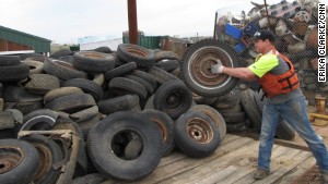
Credit: Erika Clarke, CNN
“Chad Pregracke, an Illinois man who has dedicated his life to cleaning the Mississippi River and other U.S. waterways, was named the 2013 CNN Hero of the Year on Tuesday night. Pregracke organizes community cleanups across the country through his nonprofit, Living Lands & Waters. About 70,000 volunteers have pitched in, helping Pregracke collect more than 7 million pounds of trash in the past 15 years.
“The garbage got into the water one piece at a time,” Pregracke said earlier this year. “And that’s the only way it’s going to come out.”
Pregracke was recognized Tuesday night along with the rest of this year’s top 10 CNN Heroes---everyday people doing extraordinary things to help change the world. He was chosen as Hero of the Year through a five-week public vote on CNN.com.
“I’ll just keep on cleaning up America’s rivers and loving every minute of it,” said Pregracke as he accepted the award Tuesday night. For being named CNN Hero of the Year, Pregracke receives $250,000 to continue his work. That is in addition to the $50,000 that each Hero receives for making the top 10.
On Tuesday night, Pregracke pledged to spread some of his Hero of the Year money to the rest of the top 10 Heroes. “I’ve met so many great people today, the other Heroes, and I’m really moved by all their stories and all the things they do around the world. I’m going to give 10 grand to each of them, because they’re awesome.”
Pregracke, 38, grew up in East Moline, Illinois, where the Mississippi River was in his backyard. As a teenager, he worked as a commercial shell diver and began to notice the heaps of debris in the fabled waterway, which supplies drinking water to 18 million people in more than 50 U.S. cities.
“I saw thousands of barrels, thousands of tires, cars, trucks, and tops of school buses. I got sick of seeing it and just wanted to do something about it,” said Pregracke, whom some have called “the river’s garbageman.”
For more than nine months out of the year, Pregracke lives on a barge with members of his 12-person crew. They go around the country with a fleet of boats, and they try to make cleanup fun for the volunteers who show up in each city.
They use skits, music and mock motivational speeches to get the volunteers amped up, and sometimes they even do a little karaoke. Teams also compete to see who can find the “best” garbage. “We do everything in our power to get people excited about it.” Pregracke said. “We want people to leave feeling good about what they did so they’ll come back.”
Close to 90% of what they recover is recycled. Pregracke said the rest gets disposed of properly.
In addition to the river cleanup, Pregracke has launched a floating classroom barge where his staff educates high school students and teachers about the damages of pollution on river ecosystems. In 2007, his nonprofit implemented a program to plant 1 million trees along river shorelines to protect and restore the natural environment. The group is halfway to its goal.
Pregracke says his nonprofit has already held more than 700 cleanups on 23 rivers, but he says he’s just getting started. He views his work as a different kind of service to the country.”
The nonprofit has a very interesting web site at
http://www.livinglandsandwaters.org/
Monday, November 18, 2013
Paddling the Boreal Forest

Illus.credit: barnesandnoble
Low left us little about his adventures. He lived in the day when the canoe was a tool, not a recreational vehicle. The canoe was how families moved about to follow migratory herds, how they hunted and fished, how they moved supplies into the wilderness, and how they moved furs out. For Low, the canoe transported him to find rivers, lakes, branches, mineral deposits, and reduce them to reliable maps and reports. The goal of our two authors was to follow and duplicate some of Low’s trips, and by their experience, tell their adventures and Low’s simultaneously. In their part of the world, except for what is destroyed by forest fires, little changes in hundreds of year.
Part of the appreciation of Low and his accomplishments is getting a glimpse of his Herculean determination and perseverence. At one point he had to use a sailing fishing boat for mapping. It was 28 feet long and weighed between one and two tons, and was capable of carrying two tons of provisions, two canoes, and six men. Like his canoe, this sailboat also had to be portaged across land---on rollers---through bog, rugged rocky topography, impenetrable forest, with the men being almost always soaked from continual rain. When the authors went to research Low’s field notes, century-old dried corpses of black flies fell from between the pages. In 1888, while doing the Big and Clearwater Rivers alone, Low performed 184 portages with all the boats, supplies, and surveying equipment. When there weren’t flies, they often endured temperatures between 51 and 101 degrees below zero. If nothing else, these accounts will help keep what you are experiencing on your next canoe trip in proper perspective.
Friday, November 15, 2013
Leaving a Clean Wake
This picture is not from their trip, but a sad sight that's
all too common everywhere we go.
As tough as the trip was, all went well until the next-to-the-last day. They were just getting back to “civilization”, and had to portage around the last falls. The people on both shores of the falls refused them access to their property in order to get around the falls. Kevin was truly shocked. People were portaging around falls in Canada before there was a Canada. It is a reality as expected and logical as finding gas at a gas station. How else are you supposed to get around a falls? He finally flexed his diplomatic skills and convinced the land owner that there was no alternative. He couldn’t go back the way he had come. Plus, it was a one-time deal; he had no plans to return and ask the same favor again. The owner finally relented and allowed them to cross her property, but with the admonition that it was this one time only.
Why would anyone be so disagreeable? I seriously doubt anyone would wake up one morning and decide to be obstinate enough to buck the culture and tradition of a nation so closely tied to the canoe, and thus the need for portaging. No, just as we deserve the government we get, we deserve the welcome we get, at least as a group. We are the heirs of the deeds of those who preceded us, just as Kevin and Andy were now being punished for the behavior of paddlers that had portaged the falls before. If the land owner finds strangers filling their water bottles at their home’s outdoor tap without permission, scattering their garbage around the owner’s property, mashing down their fences, or walking through their flowerbeds, no one should be shocked that those who follow will not find the welcome mat out for them.
When sailing, we had the saying that each of us should “leave a clean wake.” Right or wrong, those behind us will be judged by our actions and those who preceded us, and if we wish to go that way again, we will find the opportunities available to us before may now be absent. Each of us is an ambassador for canoeing and kayaking, and we need to protect our collective reputation tenaciously. Just as it takes a lifetime to build a positive reputation, but only one lie or deceptive act to destroy it, absent-minded or careless behavior on our part may never be forgiven nor any privileges restored. Our duty as a paddler is to leave the streams and wilderness unmarred, campsites looking better when we leave than when we arrived, and leave every person along the way a friend and supporter to all that follow. No one likes seeing trash on their property or in the wild, so if you can pack it in, pack it out. You know, do unto others as you would have them do unto you.
If you wish to see Kevin and Andy’s five-part series, you may start here.
http://www.youtube.com/watch?v=X7nPMROkWp8
Wednesday, November 13, 2013
Rocky Lake - 2
I’ve been trying to paddle Rocky Lake for two years. There is no particular reason for that other than wanting to paddle all the lakes of Oklahoma. The logic was that I’d start with the most drought stricken area first in the hope that conditions and enjoyment would improve as I moved further east.
 Conditions were horrible, but not a surprise. The travelok.com site on lake conditions was established to provide up-to-date information on lakes from both tourism and health perspectives, the latter mostly involving the presence of blue-green algae. Getting small towns to cooperate in providing timely information on lake conditions, I knew from outset, would be impossible, and I voiced that opinion to the lady overseeing the program as I wished her luck. Sure enough, the latest information is from the 3rd of July, 2012, with no update in fourteen months. Hobart’s interest in public health is best displayed by my effort to get current conditions before making the trip. I called the city to speak with the person responsible for reservoir oversight. I was asked why I wanted to speak with him, so I explained that I was coming to canoe the lake, and was looking for current conditions, like water level and the existence of blue-green algae, which can cause significant health issues. In response I heard, “What lake? We have a lake? I didn’t know we have a lake!”
 Since my arrival at Rocky Lake a year ago, the lake has been posted as closed to fishing due to fish kills from algae. The sign was still there, but I didn’t plan on fishing, and I also didn‘t plan on coming back for another try. This was going to get done. There were two issues here: water level and algae bloom.
 The sayings is, “If it’s green on top, STOP!“ Algae exists in all waters, all the time. However, their levels remain as a normal part of the ecosystem. If the water is not normally replaced or freshened by water flow or rain, and water temperatures and nutrients, such as agricultural run-off, become abnormally high, as in late summer, the algae can go into a “bloom.” At dangerous levels, blue-green algae, or cyanobacteria, will produce toxins that can cause allergic reactions like skin rashes and eye irritations, asthmatic symptoms, diarrhea, vomiting, liver and nervous system reactions. Toxicity can be particularly dangerous for small children and pets, resulting in illness or even death in extreme cases.
 The drive back to the lake was covered with debris and overgrown weeds. I could find no official site that gave water levels, but it was obvious the water was down a good ten feet. The water was as thick as a soup, and clarity reached only one-half inch. Algae was thick along both the shore and in open water. I wore 12-inch rubber boots to avoid the water as much as possible. My only exposure to the water was from sponging the mud out of Buddy before setting him back up on top the Ram. I didn’t even realize I had a hangnail on my right hand, but sure enough, by the next day it was infected. A day of Neosporin took care of it. Except for a central spine down the south end of the lake, near the dam, water was so shallow I dipped mud with nearly every stroke. At the northern end of the lake, the water was putrid and stunk badly, and most of the feeder branches was inaccessible. All I can say is that I’ve checked off Rocky Lake, and it’s history.

I'm standing at what would normally be the water's edge. There's
a drop of a couple feet off the end of the ramp, and still a good
distance to the water. The rust marks on the poles show where
the floating wharf would normally rest.

If it's green on top, STOP!

Winged bedlam as a large flock of pelicans take off.

It's not a great picture, since it's backlighted, but the stains on the
intake pipe show how far the lake level has dropped.
Tuesday, November 12, 2013
Rocky Lake
Rocky Lake is on P. 39, grid I-9 of the Oklahoma DeLorme Atlas and Gazetteer, and page 140 of the “Lakes of Oklahoma” guide by the Oklahoma Water Resources Board. It is 347 acres with an 8 mile long shoreline. It is also called Hobart Lake, as it is a reservoir for that town.
Hobart is another of those Oklahoma towns that sprang into existence overnight following the opening of reservation lands for white settlement. It has been part of the KCA Reservation (Kiowa, Comanche, and Apache). At the opening of the reservation, settlers drew lots of free Indian land. On August 6, 1901, 2,350 people descended upon the land, making it one of the smaller land rushes. They first settled in tents, giving the area the name of Ragtown. The town’s tents were gradually replaced by wood structures, and by 1903, the town had electricity and an ice plant. The name was later changed to honor Garret Hobart, 24th Vice President of the United States. Like many Oklahoma towns, its population reached a peak in 1950, and has since been in a steady decline.
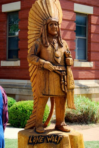 Chief Lone Wolf the Younger (1843-1923) was a Kiowa Chief depicted by a statue on the lawn of the Kiowa County Courthouse. It was carved from an elm tree by chainsaw carver Clayton Coss.
Before paddling Rocky Lake, it's important to understand how this area was settled. In October, 1867, 5000 Indians met U.S. officials at Medicine Lodge Creek in Southern Kansas to ratify the Treaty of Medicine Lodge. Kiowa and Comanche tribes were represented, but the Apaches refused to attend. The U.S. would set apart 2.9 million acres of land for the KCA Reservation, “for the absolute and undisturbed use and occupation of the Tribes.” In exchange for the 2.9 million acres, the tribes would cede 93 million acres, but no more lands could be ceded without signatures from three-fourths of all male adults living on the reservation.
In 1892, the Jerome Commission was one of 15 such commissions working to move Native Americans off the lands they had been forced to move to in the Indian Territories, and promised total dominion over. The objective was to give lands already promised to the tribes to settlers. The justifications for this action were such things as “it was God’s will,” or “the Indians didn’t know how to farm, so weren’t making proper use of the lands.” The Jerome Commission proposed changing the Medicine Lodge Treaty, but the tribes unanimously opposed reallotment, or the selling of their land, as well as any further railroad rights-of-way across their lands. They wanted their lands left undisturbed as guaranteed by the treaty. The Commission argued that the tribes did not need 2.9 million acres, but only 500,000 acres, and the remaining 2 1/2 million acres would be opened for settlers. In spite of much debating by both sides, nothing was resolved, so the Jerome Commission decided on a deception by returning to Congress and assuring them that they had the required signatures of three-fourths of the Indians needed to set aside the provisions of the Medicine Lodge Treaty.

In June 1900, Congress passed legislation taking title of the 2.9 million acres of the KCA Reservation. Lone Wolf fought for an injunction through four courts over three years, including the U.S. Supreme Court. There Lone Wolf was told that Indians were the ward of the U.S. Congress, and Congress therefore had the right to annul, abolish, or repeal “any provision of the treaty that went against the best interests of the United states.”
By July 24, 190l, over 150,000 people had registered for the lottery drawing for the 11,638 homestead sites on the reservation lands. Of the 500,000 acres the KCA were forced to accept, 480,000 acres had been set aside for common use, which meant that farmers and ranchers were free to use 96% of the Indian lands for grazing cattle. By 1906, that too had been opened for white settlement. By the end of the “allotment era,“ their 2.9 million acres had been reduced to 3,000 acres.
Following his defeat in all the courts, Lone Wolf returned to his allotment on the reservation, where he remained with his family until his death in 1923. It was not until 1955 that the Indian Claims Court finally ruled in the KCA’s favor, and they were paid $2 million for the lands they could never reclaim. The bottom line was the tribes had given up 93,000,000 acres of land for the eventual $2 million, or 2 cents per acre.
Hobart is another of those Oklahoma towns that sprang into existence overnight following the opening of reservation lands for white settlement. It has been part of the KCA Reservation (Kiowa, Comanche, and Apache). At the opening of the reservation, settlers drew lots of free Indian land. On August 6, 1901, 2,350 people descended upon the land, making it one of the smaller land rushes. They first settled in tents, giving the area the name of Ragtown. The town’s tents were gradually replaced by wood structures, and by 1903, the town had electricity and an ice plant. The name was later changed to honor Garret Hobart, 24th Vice President of the United States. Like many Oklahoma towns, its population reached a peak in 1950, and has since been in a steady decline.
Depiction of Chief Lone Wolf the Younger
Hobart, OK
Photo credit: city-date.com
Before paddling Rocky Lake, it's important to understand how this area was settled. In October, 1867, 5000 Indians met U.S. officials at Medicine Lodge Creek in Southern Kansas to ratify the Treaty of Medicine Lodge. Kiowa and Comanche tribes were represented, but the Apaches refused to attend. The U.S. would set apart 2.9 million acres of land for the KCA Reservation, “for the absolute and undisturbed use and occupation of the Tribes.” In exchange for the 2.9 million acres, the tribes would cede 93 million acres, but no more lands could be ceded without signatures from three-fourths of all male adults living on the reservation.
In 1892, the Jerome Commission was one of 15 such commissions working to move Native Americans off the lands they had been forced to move to in the Indian Territories, and promised total dominion over. The objective was to give lands already promised to the tribes to settlers. The justifications for this action were such things as “it was God’s will,” or “the Indians didn’t know how to farm, so weren’t making proper use of the lands.” The Jerome Commission proposed changing the Medicine Lodge Treaty, but the tribes unanimously opposed reallotment, or the selling of their land, as well as any further railroad rights-of-way across their lands. They wanted their lands left undisturbed as guaranteed by the treaty. The Commission argued that the tribes did not need 2.9 million acres, but only 500,000 acres, and the remaining 2 1/2 million acres would be opened for settlers. In spite of much debating by both sides, nothing was resolved, so the Jerome Commission decided on a deception by returning to Congress and assuring them that they had the required signatures of three-fourths of the Indians needed to set aside the provisions of the Medicine Lodge Treaty.

From a distance, Rocky Lake looks almost idyllic.
In June 1900, Congress passed legislation taking title of the 2.9 million acres of the KCA Reservation. Lone Wolf fought for an injunction through four courts over three years, including the U.S. Supreme Court. There Lone Wolf was told that Indians were the ward of the U.S. Congress, and Congress therefore had the right to annul, abolish, or repeal “any provision of the treaty that went against the best interests of the United states.”
By July 24, 190l, over 150,000 people had registered for the lottery drawing for the 11,638 homestead sites on the reservation lands. Of the 500,000 acres the KCA were forced to accept, 480,000 acres had been set aside for common use, which meant that farmers and ranchers were free to use 96% of the Indian lands for grazing cattle. By 1906, that too had been opened for white settlement. By the end of the “allotment era,“ their 2.9 million acres had been reduced to 3,000 acres.
Following his defeat in all the courts, Lone Wolf returned to his allotment on the reservation, where he remained with his family until his death in 1923. It was not until 1955 that the Indian Claims Court finally ruled in the KCA’s favor, and they were paid $2 million for the lands they could never reclaim. The bottom line was the tribes had given up 93,000,000 acres of land for the eventual $2 million, or 2 cents per acre.
Saturday, November 9, 2013
River Horse
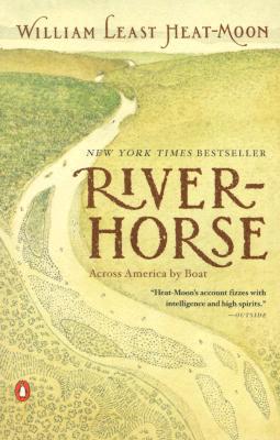
Illus. credit: goodreads.com
There are tidbits that make our history better appreciated. “Plowboy Bend bears the name of a sternwheeler sunk there…,one of more than four hundred steamboats to go down on the Missouri, half of them from hitting snags. The average life of a nineteenth-century paddle-wheeler on the river was less than two years.”
There’s a lot on environmental topics, from ranchers shoving their dead cattle, cars, trucks and machinery into the river to use it as their personal sewage canal, running barbed wire across streams to claim running rivers as private property, the greed of miners that would blow sixty-five million tons of mountain into a scenic river to claim just thirteen pounds of gold, or the sign he saw that reflects this attitude: “Hungry? Eat an environmentalist.”
If you can’t find the opportunity to make your own trip from Atlantic to Pacific, make your way through this book. You’ll enjoy the ride.
Friday, November 8, 2013
The Long Road Home
We were up early and ready to go at 7a.m., but we were greeted with a heavy downpour. We waited for a lull in the rain so I could get the RV ready without being drowned in the process. We didn’t do too badly, as we were still on the road by 8:30.

 Going down I-35, we stopped at a rest area north of Ames, Iowa, at Mile Marker 117. They had done a unique thing that was both artistic and provided supplemental lighting for the rest area during the night. Black silhouettes of Iowa cultural and historic scenes had been cut and placed over translucent boxes that were illuminated from the inside. The silhouettes were quite visible during the day, and were backlighted at night.
 At 7 p.m. we arrived at Nine Eagles State Park near the Iowa state line on I-35 (at exit 4 Hwy 69, near Davis). It’s unfortunate that the campground doesn’t seem more heavily used, as its quiet and enjoyable. There are three campgrounds in the park, and we had the campground we were in entirely to ourselves. The land had once been the home of the Winnebago tribe, but it became a state park some time after the tribe had been forced to the Indian Territories in Oklahoma. We had a very enjoyable visit from a campground volunteer whose family used to live on these lands. His grandfather was a Winnebago brave, and his mother was a McCoy, of the notorious Hatfields and McCoys, of West Virginia and Kentucky.
 By late afternoon the next day, there was no question that we were back in Oklahoma. The wind was blowing, the soil was parched, and the thermometer was topping a hundred degrees. Cool, green, and beautiful Wisconsin was too far in the rear-view to be seen, and we have just our memories to hold us over until we’re able to return.


Ames, Iowa, rest area's functional art.

Hwy. 69 was a pretty drive. An Amish wagon had us in tow for
a couple minutes. Since we were on both a curve and approaching
a hill crest, passing was impossible. When he realized we were there,
he politely pulled off onto the grass to let us pass.
Fields were filled with wildflowers. As close as I can determine,
this is checker mallow, but I won't put any money on it.
Wednesday, November 6, 2013
Joy Johnson Crosses Finish Line

Joy Johnson, named Joy because she was born on Christmas Day.
Credit: Rachael Levy, New York Daily News
Tuesday, November 5, 2013
More on Wisconsin
Sunday was an R&R day. We got up late, had pancakes for breakfast while we watched the birds, turtles, and fish outside our RV window. The Wood River didn’t look like anything we could paddle, but it was a haven for wildlife activity. I read a paddling book I’d have to get back to the library as soon as we got home, and then went over the maps to lay out our return trip from Wisconsin to Oklahoma.
 In the afternoon, Jean wanted me to see the Crex Meadows that she had visited while I was on the St. Croix. Crex Meadows is a 30,000 acre wildlife area outside of Grantsburg. It is part of the 1,500 square mile Northwest Wisconsin Pine Barrens, a sandy plain left when the glaciers receded 13,000 years ago. The glaciers left countless pockets in the soil that now provide small, shallow lakes which are ideal for birds, waterfowl, and game.
In 1912, the Crex Carpet Company purchased 23,000 acres of the existing wildlife area to grow grass for the production of grass rugs until linoleum replaced grass as a floor covering. The decline of this market drove the carpet company into bankruptcy in 1933, but the Crex name remained. Through the depression and 1940’s, many people attempted agriculture in the barrens, but the soil was not adequate to support crops, and the lands were soon tax delinquent. In 1946, Wisconsin purchased the land to create the wildlife area.
 The DeLorme Atlases are great for finding every landing and access road in an area, so we followed the atlas down to the river’s edge at Norway Point to see the St. Croix north of the wildlife area. The National Park Service publishes a very nice set of maps showing all the camping areas, put-ins, and ramps along both the St. Croix and Namekagon Rivers, as well as all the facilities at each location. The NPS tries to keep segment maps in boxes along the route, but rather than risk some of them being missing from a location when we may need them, as soon as we returned home, I called the NPS and requested the full set of maps covering the St. Croix National Scenic Riverway. Their contact information is: St. Croix National Scenic Riverway; 401 N. Hamilton Street; St. Croix Falls, WI 54024.
Phone: 715-483-2274.
 To have complete information on the area, I also obtained two books, Paddling Northern Wisconsin and Paddling Southern Wisconsin. Both are authored by Mike Svob, and they cover 27 rivers and 32 rivers respectively. While they are intended as reference books, I’ve read both cover to cover, and would strongly recommend them for anyone wishing to take advantage of the great paddling opportunities in Wisconsin. They include camping information, water levels, gradients, access locations, shuttle routes, river class, and maps for each run with mile markers. I only found two shortcomings in the books. Mike is a whitewater paddler, so he enjoys charging through any rapids, so information on portages around rapids is sparse. He considers any water that isn’t noisy and frothy to be dead water, so he ignores any information on connecting lakes along a riverway. These shortages are minor, and I still consider the books a great resource.
Last Christmas Jean also got me the DVD “River Trails of Southern Wisconsin,” done by Morrall River Films. It’s a less academic approach, but still very complete, and with the color video of the areas being paddled, the DVD is both entertaining and theraputic if weather or circumstance have you locked in the house too long. In any event, the final point to stress is that I’m greatly indebted to Rex Klein and the Great River Rumble for introducing me to this stunningly beautiful area. I can’t wait to get back. Let’s face it, with 59 rivers and 15,074 lakes in Wisconsin, each surrounded with natural beauty, interesting history, and wildlife, what more needs to be said. See you there!

Phlox at James McNully Campground

Gathering pollen.

Last Christmas Jean also got me the DVD “River Trails of Southern Wisconsin,” done by Morrall River Films. It’s a less academic approach, but still very complete, and with the color video of the areas being paddled, the DVD is both entertaining and theraputic if weather or circumstance have you locked in the house too long. In any event, the final point to stress is that I’m greatly indebted to Rex Klein and the Great River Rumble for introducing me to this stunningly beautiful area. I can’t wait to get back. Let’s face it, with 59 rivers and 15,074 lakes in Wisconsin, each surrounded with natural beauty, interesting history, and wildlife, what more needs to be said. See you there!
Subscribe to:
Posts (Atom)