Wednesday, February 29, 2012

Thistle Makes Room for Paddling


I thought I’d be sailing until the day I drew my last breath, but as the saying goes, “Life is what happens while you’re making other plans.” Being in Northwest Oklahoma made sailing impossible, thus my move back to paddling. So Thistle has been here patiently waiting on the trailer while I make up my mind. I hate to let her go, but if I can’t use her, and sitting here on the trailer just lets time eat away at her, just making for something else I need to maintain, it’s time to make the move. I’ve listed her on two sites so far. If you know of anyone interested in a great sailing boat in excellent condition, check out the ads.
Sailboat Listings.com at
http://www.sailboatlistings.com/sailboats_for_sale/
And Sailing Texas at:
http://www.sailingtexas.com/cboats.html
Look for the 1981 25-ft. Dufour, Model 1800.
Cheers, jim


Monday, February 27, 2012

Dead Indian Water

Credit: Photobucket

There’s great joy in paddling serene waters, watching the natural land and rock formations glide by, and looking for the wildlife that call the area home. I can’t avoid thinking about the history of the people that lived, hunted and fished the area for thousands of years before. Whenever I get into studying the history of Oklahoma, however, I find myself unavoidably hanging my head in shame. The lands of Oklahoma were given to the Indian tribes, or rather they were forced onto these lands. This was because of the belief as far back as Lewis and Clark, that the land was worthless and unsuited for habitation by the white man. When the emigrant populations continued to push west, that view was changed, and for one reason or another, justification was found for confiscating the land back from the Indians. The Indians died on the trail while being forced to occupy the land, as many as 4,000 died on the Trail of Tears alone, and they died once on their new land because the food and supplies promised to them by the Federal government to start their new lives or get them through the first winter just never materialized. Then once they got settled, the land has systematically been stolen back from them.

When planning for a local paddling trip, I looked at Dead Indian Lake. It apparently has had three names over the last decade---Dead Indian, Dead Warrior, and Black Kettle. Of course there are no natural lakes in Oklahoma, so the name originally applied to the creek that was dammed. It was originally given the name Dead Indian because a Cheyenne burial site was discovered by the first settlers among the cottonwood trees by the creek. Coming into the age of political correctness, it was decided that wasn’t racially sensitive enough, so the Dead Indian was promoted to a Dead Warrior. Feeling that was still inappropriate, it is now the Black Kettle.


Another local example is that of Fort Reno, located about 30 miles west of Oklahoma City. In 1874, Army officers were directed to establish a staging area south of the Canadian River from which to dispatch patrols during the Indian Wars. Once the site became established as Fort Reno, the Federal government confiscated 9,500 acres of Cheyenne-Arapaho tribal land around the fort. As recently as 2000, when considering continued funding for an Oklahoma State University livestock research center there, Republican Senator Don Nickles incorporated language in the funding bill that would prohibit transfer of the land back to the Cheyenne-Arapaho because there was the belief that oil and natural gas may be under the land. (Source: Bill Moyers)

Similar battles are now taking place over Indian water rights. A lot of the state’s lakes are on tribal lands and under their ownership. In an effort to create a long-term water use plan, the Choctaw and Chickasaw tribes tried for seventeen years to get the State of Oklahoma to join them in creating such a plan to meet the water needs of all Oklahomans, but the state was unresponsive. The tribes weren't claiming sole ownership of the waters of Sardis Lake, but only wanted to be recognized as co-owners so that state wouldn't be issuing water-use permits without consulting them.  Even when Texas sued Oklahoma in 2007 for water usage, because they wanted the water downstream for Dallas and Ft. Worth, the state still dawdled. Finally, the tribes tried to force the state into joining them at the table to create a plan. Since water was becoming an issue for Oklahoma City, the tribes understood water-use would eventually have to come to a head. The state responded by suing the tribes for water rights, a response one person characterized as “swatting a gnat with a sledgehammer.” This is expected to lead to a ten-year court battle that will cost millions of dollars in legal costs. I wonder who will win this fight.


Sunday, February 26, 2012

Back to Planning


Some of the lakes in the eastern part of the state are reaching conservation pool levels, which is their way of saying the water is back up to normal levels. The ones in the western and southwestern portions are still suffering for water. For example, one of the largest lakes in the southwest is Altus Lake, which is down 82%. Optima Lake in the northwest was built in 1978, and has never reached normal pool level. It has just a little puddle at the base of the dam, and that’s it. Between the lack of rain and rapid evaporation in the normally arid air, there is just no water.

At any rate, I’ve gone looking for paddling opportunities, and have found a great tool for that search. The Oklahoma Water Resources Board publishes a book titled “Lakes of Oklahoma.” It has charts for 144 lakes in the state. They are printed on sturdy, gloss-finished paper and in a spiral-bound book. Each chart includes valuable information on the lake, from the managing authority, acreage, capacity, shoreline length, date of construction, and the availability of ramps, picnic areas, campgrounds, as well as maps showing routes into the various features. It is free if picked up at the OWRB office, or $10 by check for shipping if ordered by phone.

Of course water is not the only problem here. I need to watch for the wind to die down. The last couple days, the wind has been blowing 40-50 mph. Last Tuesday it was gusting 80-90 mph and tore a couple’s home apart, killing the woman inside. But, I’m anxious to get the paddle wet again, and this book of maps should be a help.

Friday, February 24, 2012

On The Road - 8

David and Margie Hawkins
Joe and Ruth Kliment
and
Paul and Margaret Higbee, whose picture I can't find for some reason.
Thanks to all.


The auto center opened at 7, so I was up at 5:30 to get breakfast and be at Wal-Mart’s tire center when they unlocked the doors. I was moving north. It was 41-degrees and time to put the flannel shirt back on.

I had never before had a vehicle where the wheel didn’t just fall off when the lug nuts were removed. The repairman explained it is now becoming a common problem, especially with dissimilar metals, like aluminum wheels on steel hubs. The problem is worst on vehicles where salt is present, either from living along the coast or where salt is used for snow and ice removal. He told me I had really bent the wheel while hammering on it, but the tubeless tire had sealed. He recommended two solutions: remove all the wheels and apply liberal amounts of waterproof grease (lithium) to both the hub, studs, and wheel where they meet, and second, buy the largest, meanest rubber mallet I can find and leave it in the vehicle with the tire-changing tools. One can never stop learning. Also, the interior of the tire had delaminated in the time it took to get off the highway, so it couldn’t be repaired. The size of the chunk of steel in the tread would probably have ruled out a repair anyhow. Replacing the tire was an additional $195 expense I could have done without, but it is just one of those risks on a long trip.

By the time I hit the Oklahoma state line, I ran into the next storm system and had torrential rain the rest of the way home. The trip through Oklahoma City on I-40 was the worst. The multi-lane roadway has no reflective lane markings, and the heavy rain turned the roadway into a black mirror that made it impossible to know what lane one was in. It twists and turns and dips its way through the city with water pooling and creating hydroplaning hazards. The risks combined to produce one multi-vehicle crash on my route through the city. I finally crossed the threshold at 11 pm. The road trip totaled 3,743.1 miles.

Tamia Nelson, of paddling.net, once wrote that in the process of shuttling and reaching paddling locations, one could count on having to drive ten miles for every mile paddled on the water. I thought that was horrible. On this trip, however, even with a 115 mile paddling trip, I still drove 33 miles for every mile paddled. Wow!

To all the friends that helped along the way, and all those who shared the experience, my sincerest appreciation for sharing the adventure. Thank you, and I hope we can do it again.


Thursday, February 23, 2012

On The Road - 7

Bahia Honda Sunset

Getting to the end of the account of the trip is as depressing as was getting to the end of the trip. Now it’s back to reality. With farewells to Joe and Ruth, I left Punta Gorda at 6:30 the next morning. It was 63 degrees, and the sun was just starting to lighten the horizon. By the time I reached North Port, the temperature had dropped to 57. That was just enough to dip below the dew point and bring on a thick fog.

In the on-going effort to see as many friends as possible, I had contacted a long-time friend from Homerville, GA. Paul Higbee had arranged to come down to St. Marks to combine a couple days of fishing, and a chance for us to get together for lunch. I met him at his campground, and we went out to the Dockside at St. Marks and spent a couple hours together before it was time to get back on the road.

A strong storm front was moving east that had brought tornadoes to Alabama the night before. I met the system at Dothan, AL. I continued through the pouring rain for about 40 miles and was able to punch through the west side of the system and continued on.

I was approaching Clanton, AL, when I felt a rough vibration. As first I thought it was the road, but it didn’t look any different, so thought I’d get off at the next exit to check the tires. I pulled into a Texaco convenience store. Sure enough, the right rear tire was going down fast. By the time I had the jack and tools out, the tire was completely flat. I had picked up not a nail or screw, but a fairly large piece of steel. Then the fun began. The wheel had fused to the hub and I couldn’t get the wheel off. I kicked and beat on it to no avail. The gas station had no tools but a carpenter’s hammer. I crawled around on the ground and under the truck for two hours trying to break the wheel loose. The hammering was hard enough that I was driving the truck off the jack, so I had to let it down, reposition the jack and try again. Going from one business to another, I finally found a Scottish Inn that had a sledge hammer in its maintenance closet. The wheel finally came off, but by then the Wal-Mart auto center had closed, so I was unable to get the flat fixed, I spent the night at the motel. I’m glad I got off the highway. If I had stopped on the roadway, I would have been out of luck.


Wednesday, February 22, 2012

Florida Keys Challenge - 11

The Disney 'Magic'.

Bill Richards anticipated some media being present when we made landfall at Key West. It was a big weekend for the town, as it was the 100th anniversary of Henry Flagler’s arrival in Key West on his recently completed railroad. Crowds and a parade were expected.

I was first off the beach at Boyd’s to get an early start so we could all arrive at about the same time. We were to land on the very west end of Key West, on the beach at Whitehead Spit, and on the grounds of Fort Zachary Taylor State Park. We landed right at the edge of the commercial channel into the port of Key West as the 964-foot, 83,000 ton Disney cruise ship “Magic” made landfall with her 2,700 passengers and 950 crew. The paddle from Stock Island to Key West had been 6.8 miles, making a total for the event of 114.9 miles.

Our landing on the beach at Ft. Zachary Taylor State Park, Key West.

What our group was doing from here varied. Some were taking time in Key West to take part in the festivities, and some were taking boats to the Dry Tortugas. Some, like myself, were determined to be out of town before our hulls got dry or the parade started. I was on the express for Oklahoma. I had registered for two photography courses at the local vocational school, and while I would miss the first class on Monday, I was determined to get home in time for the Wednesday class.

I got Ibi on the canoe cart and hauled her to my Dodge Ram, which had been patiently waiting here for the last week and a half. Once it was loaded, I loaned the canoe cart to Gus so he, Carl and Bill could get their boats off the beach and to the parking lot. Doug Alderson had left his car at Curry Hammock, so we also loaded his kayak on the Ram next to Ibi. There was a quick BBQ lunch, and I got a chance to say ’goodbye’ to a few of the folks. What can you do when you’ve shared an experience with such a large group? I felt quite inadequate in making an adequate farewell, so made my departure from those I could, and just hoped the others would know that I’d hope to see them again somewhere down stream.


As Doug and I pulled through the state park, the parade was forming in the field near the exit. What timing! There was just one more official act. We drove down Whitehead Street to the dead end to photograph the marker that identifies the southern-most point in the continental United States. Then it was pedal to the metal at 20mph as we left Key West. We made a quick stop to deliver Doug and his boat to his car at Curry Hammock State Park, and then it was north again. Doug was gracious enough to give me one of his other books to read to the grandkids, “The Ghostly Ghost Tour of St. Augustine and Other Tales from Florida’s Coast.“ I was trying to arrive back at Joe and Ruth Kliment’s at a reasonable hour in Punta Gorda.


Tuesday, February 21, 2012

Florida Keys Challenge - 10

No. 1 is our departure from Sugarloaf KOA, No. 2 is our lunch stop at Sammy Creek,
No. 3 is our arrival this day at Boyd's Campground, and No. 4 is
the last day's sprint to Key West.

I managed to be first off the ramp in the morning. It would be our last long paddle, and I wanted to get a good start. Another problem with being in the back of the pack is that any wildlife that might be happened upon is long gone before the rear guard paddles through. This morning I paddled close along the mangroves and saw assorted birds galore. We just followed the shore of Sugarloaf until we reached Sugarloaf Creek, also called Sammy Creek. The road crosses the creek there, and a picnic area has been built right on the point. That made our lunch stop.
Pelican

As I approached shore, it was evident the entire area had been filled with crushed limestone. It had the appearance of having a very solid shoreline as the crushed stone spread into the water. I pulled parallel to the shore, stepped our with my left foot, and prepared to stand up. Suddenly the rock was sinking beneath me into the bottomless mud. My left foot was locked in the mud, and the canoe was slowly moving from beneath me. As I began to do a split, I was about to make a very unceremonious splash when someone fortunately grabbed Ibi’s bow. When I got ashore, I learned another paddler had faced the same situation, but not having a savior to lend a hand, ended up going for a swim.

If you can pick them out. there are four tents and a picnic table in the one small
space where the clothes are drying between the two trees.

After leaving Sammy Creek, we passed Saddlebunch, Pelican, Saddlehill, Geiger, and Boca Chica Keys. Once you reach the mouth of Boca Chica Channel, Stock Island lies ahead, and wildlife and mangroves are replaced with commercial enterprises. Many shoals litter the harbor mouth. Once you make your way up the channel, Boyd’s Campground is found on the east shore of Stock Island close by the Overseas Highway bridge. When I made landfall, I learned there were still fifteen boats behind me yet to arrive. The campsites here are very small. Every effort is made to maximize the available ground. Campsites are barely large enough for a car and tent, but for economy we needed to pitch four tents per site. There were literally only inches between tents. This would be our last night. Our last real paddle had been 18.6 miles, the same as our first day.


Monday, February 20, 2012

Florida Keys Challenge - 9

No. 1 is our departure from Bahia Honda State Park; 2 is our lunch stop on
Long Beach, and 3 our arrival at Sugarloaf Key KOA Campground.

The morning we prepared to leave Bahia Honda State Park brought us yet another spectacular sunrise. Today would be the only day that chow wasn‘t carried ahead to our lunch stop. After breakfast, we all packed bagged lunches to carry with us. It would be one of our longer days, so we didn’t tarry.


The crossing of Bahia Honda Channel was maybe worse than the larger seas we had experienced before. They weren’t bigger, but came from about five different directions at once. Instead of coming as waves, there were just eruptions of vertical spikes of water everywhere and without warning. There was no rhyme nor reason to the water, and it was impossible to predict what was to happen next. It was very discomforting, and like being in a washing machine.

The nickerbean pod.

The nickerbean can be found throughout the tropical hammocks and mangroves of the Virgin Islands, Hawaii, West Indies, and Bahamas. In the United States it occurs in the Keys and as far north as Central Florida, but no where else in the country. They have been used to treat malaria and the pain of toothache. The gray seeds will take on a bright shine, and were the original ‘pet rocks’ (Yes, actually referred to by that name.), and carried by children to play with, or wear on a necklace.

Our scenic lunch stop on Long Beach, Big Pine Key.

Here’s a good place to bring up the subject of the lazy ’H’ I mentioned at Lower Matecumbe Harbor and promised to get back to. If you go back, it is at L24.8503N Lo80.7458W, this is what you see in the harbor just south of the BSA Sea Base.


Flagler sent a crew to Key West to build a commercial marine port. He wanted Key West to be his railroad’s terminus for cargo in and out of the U.S. Freight could travel down the East Coast on his rails to be loaded on ships for foreign ports, and be imported into the country the same way. When his crew reached Key West, they contacted Flagler and reported there was no land to build his port on. His single-mindedness was never more evident than when we answered something to the effect of “Well, then make some.” The shallow bottom would be excavated to make land, and the result would be deep water right alongside major construction. Thus, the deep ‘H’ (excavated area) and island (where the bottom material was deposited) appeared where none had existed before. (The white dots to the left are the concrete railroad trestles left after the hurricane.) This practice continues to today. The result is that you can be a half-mile offshore and perhaps not have enough water to float a kayak or canoe, but if you get within feet of shore, you can often find water so deep you can’t see the bottom in crystal clear water.

Sugarloaf pier and Oversea Highway bridge.

With the falling tide, there were grass flats we’d be unable to get across. We ran from the end of Summerland Key, past beacon “18” and straight for the elbow in the peninsula, while leaving Venture and Out Keys to port. We could see some fishing boats alongside a quay against the shore, so knew there was water there. We followed the shore west and around inside Gopher Key by paddling under mangroves and through one mangrove tunnel within ten feet of shore. Once we got around to the northwest point , we were clear of the shoals and able to make a shot across Cudjoe Bay and up Bow Channel. The Sugarloaf Key KOA campground was right next to the south side of the bridge. Here we had a paved ramp to pull out on, and a large wooded grove in which to camp. The day’s paddle was 16.4 miles. We were in the groove and going well, but unfortunately realized our adventure was winding down to its inevitable end.


Sunday, February 19, 2012

Florida Keys Challenge - 8

The sweeping beach of Bahia Honda.

Our lay day on Bahia Honda gave us a great chance for rest, reading, exploring the island, laundry, and fishing. I’m not a fisherman, but as a tangent for those who are, note that I’ve added a new link by Jason Self in the right margin called Kayak Angler. You may find it interesting.

The old Rt. 1 now framed by a grove of sea grapes.

The old Bahia Honda Channel bridge spans 5,055 feet. Its approach is now abandoned and framed by sea grapes. The road bed is now a tourist path from the state park up to the deck of the old bridge. They finally had to re-deck and add width to the roadway. It doesn’t take much imagination to look at this bridge and visualize the pieces of side-view mirrors and fenders scattered on the roadway.

After the railroad right-of-way was sold to the State of Florida, the road deck was
built over Flagler's railroad trestles.

Compare Flagler's roughly 105-year old concrete work with the much
newer concrete work of the highway department.

I find the character of Henry Flagler, like other successful people, as revealed by his projects as interesting as the projects themselves. There is a single-mindedness that I wish I had understood when I was much younger. When he revealed his plans for building his railroad bridge to span the Keys, he was told it was impossible. Even after his successes in creating Standard Oil and the projects of St. Augustine, he was still told it couldn’t be done. He, on the other hand, couldn’t see why everyone thought it was such a big deal. He said, “It is perfectly simple. All you have to do is to build one concrete arch, and then another, and pretty soon you will find yourself in Key West.” Or, as I will elaborate tomorrow, when told there was no land to build a seaport on, he responded, “Well, then make some.” Along with single-mindedness was commitment. The railroad was started in 1905 and would take until 1912 to finish. Over 10,000 men worked to make the dream of one man a reality.


Crossing Bahia Honda Channel.  The current Overseas Highway is seen
in the right edge of the picture.

Also, he was very attentive to details and was quick to change his approach to a project based on what he learned in the process. Wanting to use a concrete that would work well in sea water, he found a mixture he liked in Germany and imported it to the Keys. Realizing that steel reinforcement would rust when concrete was mixed with salt water, he carried fresh water from the mainland. I was told that this hundred-year-old lesson wouldn’t be RE-learned by the Florida Department of Transportation until about 20 years ago. In Flagler’s era, carrying cement from Germany, and every gallon of water up to a hundred miles or more to the construction site, would not be too unlike us now starting a major project and having all the building materials brought in from the moon.

Our camp site from the old bridge.

While the railroad opened the East Coast, brought life, commerce, and tourism (something that had never really existed before) to Florida and the Keys, it never made a penny of profit for Flagler. It operated from 1912 until 1935, and was then driven into bankruptcy by two events---the Great Depression and the devastating hurricane of 2 September 1935. The Labor Day hurricane, the third strongest ever to hit the United States, produced 185-200 mph. winds and a 20-ft. storm surge. It has been surpassed only by Wilma in 2005 and Gilbert in 1988. To put the storm in better perspective, Katrina, still fresh in our memories, ranks sixth. Also, remember the average height of the Keys above sea level is only ten feet.

Hurricane Memorial
Credit: google pictures

The hurricane killed 408 people, nearly all of them in the Keys. The ten-car evacuation train was swept from the tracks with only the locomotive remaining. The bodies of those who lost their lives were recovered from all over the Keys, Florida Bay and Cape Sable, the tip of the Florida peninsula. About 300 of their remains were cremated and interred in a tiled crypt at the foot of the Florida Hurricane Monument on Islamorada Key. A large percentage of those lost were World War I veterans that had rushed to the Keys in search of work on the construction of U.S. Rt. 1. The railroad would never be rebuilt, and the right-of-way was sold to the State of Florida for the construction of the Overseas Highway, which would extend Rt. 1 to Key West.


Saturday, February 18, 2012

Florida Keys Challenge - 7

Icon 1 is our departure from Knights Key Campground.  No 2 is the stop at Molasses Key.
No. 3 is the lunch stop at Money Key, and 4 is the stop at Bahia Honda State Park.

In his talk last night, Bill Burnham explained how the mangrove propagates itself. The seed grows to take on the appearance of a slightly bent cigar. It drops into the water and drifts as the seed absorbs water. It first drops one end to continue floating vertically, and later sinks to the bottom to set its roots. As each branch grows, it sends down supports into the bottom so it just keeps spreading. The Seminoles thus called it a walking plant.

A mature mangrove.  Notice the supports from every branch to the bottom.

The high tide was early and was forecast to drop very quickly, so we rushed to break camp, eat, and get our boats across the rocks and into the water before the tide left us high and dry. We were anxious to avoid dragging our boats across the flats again. The last boats were out by 7:45. A few even chose to skip breakfast and lunch altogether to make the crossing. This was our longest crossing in open water, from Knights Key to Bahia Honda, crossing the area spanned by the Seven Mile Bridge.

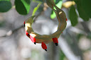
A newly rooted young mangrove plant.

Lunch was originally planned for Molasses Key, but was changed to Money Key. By the time we had gotten that far, the lead boat was long gone from view, and a separate group that had been paddling together suddenly found themselves stranded with an empty horizon. One of the greatest rules of good seamanship is to always do your own navigation and not rely on that of others, but we had lapsed into the habit of playing follow the leader. Now we had neither a leader, nor anyone to follow. We went to the first Key, landed and waded ashore, only to find ourselves alone. I dug out my charts buried in Ibi’s bow to figure out where we were. We had in fact landed on Molasses Key, and once it was obvious where Money Key was, we set off again and homed in on lunch.
The Portuguese Man-of-War. 

The Portuguese man-of-war deserves special mention.  It is not a jelly fish, but a colony of individual zooids that cannot survive independently.  The bladder is filled with mostly carbon dioxide for flotation, and topped with a sail.  It has no means of self-propulsion, but is moved about by the sea, current, or the wind.  It will periodically flop over to keep the membrane moist, and can deflate so it will sink beneath the surface if conditions are rough enough to damage it.  The tentacles will stream behind a mature man-of-war for 30 ft., and have been measured up to 165 ft. in length.  Each tentacle contains thousands of stinging cells that will leave a burning rash for 2-3 days.  They can cause death in small children, the elderly, or the unhealthy, but that is very rare.   After removing any remaining remnant of the tentacles, flush with salt water.  Follow that with hot fresh water, which will dilute the toxins and ease the pain.  Do not rub with the hand while flushing, as toxins can cause secondary burns to the hand or other skin they are being rubbed over.  Contrary to popular folklore, do not use vinegar, as that aggrevates the burns.  Keep an eye on small children playing along the beach for any man-of-war washed onto the sands. 

During the crossing, the wind was calm and the sea flat, so I got a chance to see dozens of Portuguese Men-of-War, more red starfish, and hundreds of various sponges.  There were man-of-war as small as a pencil eraser, but the float will reach 12-inches in length. 

The total paddle for the day was 11.4 miles, and took us beside a long span of Henry Flagler’s bridges. After dinner, Monica Woll, Florida Keys Overseas Heritage Trail staffer, gave us a great historical account of Flagler’s Folly. (Monica was also the one that identified the plants I had photographed on Long Key’s nature trail.) Once the Folly was completed, many called it the Eighth Wonder of the World. It opened up Florida, connected Key West, the largest city in Florida at the time, to the rest of the world, and gave the new automobiles being produced by Flagler’s friend, Henry Ford, a great and new winter destination.


Part of the Seven Mile Bridge with Don Quixote Key framed beyond the bridge.

Ibi pulled up on Molasses Key with the Seven Mile Bridge beyond.

We would spend a lay day at Bahia Honda. We didn’t have to jump up the next morning to break camp, and we had some time to get a few more sunrise and sunset pictures, rest, and wash out some paddling clothes with sufficient time for them to dry. I pulled out the “Voyage of the Ant” to read in the shade.
A red star fish, one of many seen while approaching Money Key.

Friday, February 17, 2012

Florida Keys Challenge - 6

Credit for all the maps I've used to write on goes to paddleflorida.org.  Icon 1
marks our departure from Curry Hammock State Park.  The route shows us going into
Vaca Bight and closer to shore. In practice, we paddled the rhumb line from point to point.
No. 2 is our lunch stop at Sombrero Beach, and 3 is our landing at Knights Key.

Our lunch stop on Sombrero Beach.

Today brought us a 3.7 mile open water crossing of Vaca Bight and past the Marathon Airport. The open area brought us mostly 2-ft rolling waves with occasional 3-ft. breakers. We got a break once we rounded the point inside of East Sister Rock. It was a total distance of 7.7 miles to our lunch stop at Treasure Island’s Sombrero Beach. In this case the tide worked to our benefit. We needed a higher tide for our landing at Knights Key Campground, so this was a case of man waiting for time and tide as we took a long lunch and stretched out on the ground to rest and nap.

Once we cleared the beach, we headed up Sister’s Creek and turned west through Boot Key Harbor. At Knights Key, we made a difficult landing on rough, slippery limestone rock. We had laundry facilities, hot showers, and a large open primitive camping area that gave us the chance to spread out.  the total distance for the day was 11.0 miles.

View of the Seven Mile Bridge from the Sunset Grill at Knights Key.
There's no land out there!  The hump in mid-screen is an elevated bridge to
allow transit of the channel by larger vessels.

Once we got our tents set up and showered, Carl and I went exploring, and found our way to the Sunset Grill. While we enjoyed Happy Hour, a snowbird from Illinois commented that what we were doing looked like great exercise. I smiled and said, “We passed exercise some time back. We’re now into endurance.” We were slowly becoming the aged and infirm. My back and right shoulder were complaining. One paddler wrenched his back while manhandling his boat and was enduring muscle spasms. While getting over the slippery limestone with his boat, Carl had fallen twice, bruised his right hip on the rocks, and ended up stiff and sore. The interesting thing that I would discover later was that this was the low point. From here we began to settle into the routine, and I began to feel stronger. By the trip’s end, I’d be feeling better than when I started. If I could have taken a lay day for laundry and rest at the end, I would have been ready to go another hundred miles.

 
After worrying so much about keeping pace with the kayakers, this evening I had a really nice bit of affirmation. One of the more experienced kayakers said, “It amazes me how you’re able to drive that canoe as hard as you are.” That was great, and was just the little “atta-boy” I needed. By the end, two others would make similar comments, so maybe I was doing okay. Still, I will stick to my recommendation that matching your boat to most or at least some others in the fleet would make the effort a lot easier.


Credit: Amazon and Bill & Mary Burnham

After dinner, we enjoyed a presentation by Bill and Mary Burnham. They are the authors of the “Burnham Guides: Florida Keys Paddling Atlas.” If you are considering a similar trip, all concerned seemed to agree that this is the best guide available, and Bill Richards added it was used by him for most of the planning of the Keys Challenge. It was also the winner of the 2008 National Outdoor Book Award.
http://www.burnhamguides.com/

One of the most critical ingredients in making a successful trip is the people making up the party. Just as we were blessed by great weather, and we were even more blessed by a wonderful group of paddlers. They very quickly transformed themselves from a crowd of individuals to a cohesive team. There were no slackers, and no greedy or self-serving members. Whether it was helping move boats, helping people land or get off the beach, or helping move bags in and out of the truck, everyone was equally willing to jump in and lend a hand. If something was needed that wasn’t in the first aid kit, a tent peg hammer was needed, whatever, there was always someone ready to jump in with what was lacking.
Gladys is ready to go.

Michigan was at the forefront for organizing a group of 16 paddlers for the trip to Florida and the Keys Challenge. Laurinda Bedingfield, of Boston, perhaps feeling uncertain about how the trip would go, called herself the chicken lady, and brought Gladys as her boat’s figurehead. Gladys was great fun for everyone, and several times Laurinda returned to her boat to find that Gladys had laid a hard-boiled egg, and once a granola bar. But my hero in the group was Sally. From Vermont, she had lived and camped in Alaska, backpacked in Labrador, and at 79, was tireless and independent, and a strong paddler. As soon as she got in the boat, she was off and gone. Between her, her son John and daughter-in-law Ann, it was interesting to watch them as they experimented with different sail rigs and took turns among their three boats.


Thursday, February 16, 2012

Florida Keys Challenge - 5


You can’t say enough about the beautiful sunrises and sunset in the Keys. The sunrises really make it worthwhile getting up, and today brought another beauty. As the mare’s tails predicted, today would be our third day under small craft warnings. In retrospect, however, the common theme among all the participants was how wonderfully blessed we had been with the weather. The strong system Joe Kliment’s forecast had predicted never got far enough south to bring us those 35-40 kt. winds. We never had a headwind the whole week and a half except for a short 7/10 of a mile going into the Boy Scouts Sea Base and 8/10 of a mile coming out of Boyd’s the last morning. The rest of the time, the winds were occasionally on the beam, but mostly on the stern or either quarter. It shocked the heck out of me, and I doubt few future Challenges can hope to see our experience repeated. I’ve looked at the Pacific Action Sails for a couple years, but haven’t made the investment because they are downwind sails mostly, and I never go downwind. I’m so used to beating into a headwind, I was beginning to doubt it was possible to paddle a canoe downwind. On the second, third, and fourth days we did paddle under small craft warnings, but the offshore reefs kept the waves in check. Mostly we could stay in areas with mere ripple to waves of a foot. While offshore seas were building to 8-10 feet, according to the weather service, we never saw waves of more than 2-3 feet except for a few four-footers kicked up by opposing wind and current. One paddler said he saw six foot waves, but waves always look big when you are sitting basically on the water‘s surface. From that perspective, a six-foot wave would completely blot out the horizon. However, that’s not to minimize what we did encounter. They were great skill and confidence builders.   

Icon 1 is our departure from Long Key, 2 is our lunch stop on Conch Key, a
mere knoll of sand crossed by the Overseas Highway, and 3 is our arrival at Curry Hammock.

Doug Alderson came in late last night. It was great to see him again after having the chance to paddle with him on the Gulf Coast last year. He was to take the job of stern sweep for the rest of the Challenge, and to make the pain of being last less onerous, he dubbed the rear of the fleet Margaritaville, and invited one and all to join him in the back of the pack. That’s the imagination you could expect from an accomplished author. The meet gave me the chance to pick up his latest book, “Wild Florida Waters: Exploring the Sunshine State by Kayak and Canoe.” If you are not familiar with his work as naturalist, photographer and author, check out: http://www.dougalderson.net/

Our lunch stop on Conch Key.

It was 4.4 miles across Long Key Channel from Long Key State Park to our lunch stop at Conch Key. One person opted out of the trip across the channel, perhaps because of yesterday’s experience, or perhaps because of the channel’s reputation as a conduit for large sharks, especially large hammerheads, making their way from one side of the Keys to the other. The afternoon paddle took us past Duck Key and Grassy Key. The total distance for the day was 11.6 miles, and it brought us to Curry Hammock State Park on Little Crawl Key.


Channel entrance to Curry Hammock State Park.

The area where we camped is normally a day-use area, so we had to have a special permit from the Park Service. There were nearby showers, however, where I took a double shower--part with my clothes on and part with them off. I guess that made today laundry day. The miracle of all polyester clothing made it possible to get clothes dry quickly.


Curry Hammock iguana.

During the evening, we had a presentation by a young biologist/photographer from the National Audubon Society. The Audubon Society is about much more than birds, and is about conservation and preservation in general. He spoke on the ecosystems of the Everglades and Florida Bay.


Florida Keys Challenge - 4A

While reading “The Everglades: River of Grass” by Marjory Stoneman Douglass, I happened on a point of interest concerning Matecumbe Key. Matecumbe, of course, is where we stayed at the BSA Sea Base. The Spanish from Havana were trying to convert the Key Indians to Catholicism, and had built a small fort near the Indian village on Matecumbe to operate from. The governor on Cuba ordered the priests and soldiers to leave, as he felt the site was indefensible and their efforts unlikely to prove fruitful. They tore down the fort, and the English gained control here and through the rest of Florida. The interesting point is that Matecumbe Key was the site of the last Spanish control and possession in Florida before the peninsula fell under English possession.  It always amazes me when I realize I'm walking in the steps of the oldest Keys Indians and Spanish explorers that contributed to this nation's earliest history. 

Wednesday, February 15, 2012

Florida Keys Challenge -4


Icon 1 is the departure from BSA Sea Base, and 2 is the beach at Long Key SP.

With the help of a couple paddlers, I got Ibi in the water and was second off the beach. By the time I had reached the end of the causeway, I had been overtaken by the pack, and crossed with them back under the bridge. Once we had crossed the three-mile wide channel to the east end of Long Key, we ran into a low tide grass flat. There was not enough water to float our kayaks and canoe, so we had to get out and pull our boats about 150 yards across the shoal until we again reached deeper water. The sandy bottom looked perfectly flat, but I found myself stumbling along as there were holes that I stepped into. They looked perfectly level with the rest of the bottom, but the material that filled the holes had no substance and my foot would just sink until it found firm bottom. Most were just a few inches, just enough to throw me off balance, but I fell in one and sank clear to my crotch. Oh well, that was just the price for seeing a huge red starfish.

Beach landing at Long Key State Park

This would be our second day of small craft warnings, but the wind against current flowing in the wide channel would give us our largest seas. Most 3 and 4ft. seas wouldn’t be a problem in open water, but the current produced seas that were short in period, steep faced and breaking. I tried to keep the breaking seas on my starboard quarter. When I heard one breaking behind me, I’d kick the rudder to straighten the canoe and take the sea more on my stern. On one, however, the rudder was already in white, aerated water and had no effect. I tried to paddle the canoe around, but the wave had already yawed me around sideways, and I surfed the breaking wave broadside. Now that was a ride.

Crystal-clear water and snow-white beaches.

I later learned that another paddler, coming right behind me in the same area, was undoubtedly experiencing the same conditions when he was flipped. A nearby Coast Guard Auxiliary boat quickly got him back in his boat, and he pressed on, but the capsize had caused him to lose a few minor pieces of gear. I think we were actually fairing better than the Auxiliary crew. They were anchored in a much larger boat, but the breaking sea was knocking them all over the cockpit, and I’m confident they went home with more bruises than we received. It was a short paddle today, so there was no separate landing for lunch, and we continued on to the Long Key State Park at the southeastern end of the island. The day’s paddle was 6.9 miles.


Long Key has a wonderful nature trail, and the short day gave us the chance to enjoy some new sights in the tropical hammock. After setting up camp just off the white sand beach, we got a chance to stretch our legs. The underbrush was just alive with butterflies.

Cat's Claw seed pod.

The bright red velvety seeds of the Cat’s Clay immediately caught my eye. There are several plants called Cat’s Claw, and it is being learned that some are promising in the treatment of cancer, AIDS, leukemia and other ailments.
Poison Wood tree.

The poisonwood tree is a member of the poison ivy family. Contact with virtually any part of the tree, which can grow to 60 feet, will produce a terrible rash and second-degree burns. Its smoke, or even its pollen, can carry the toxins into the eyes and lungs. The rash is a photo-toxin, meaning being in sunlight makes it worse. The sap is not water soluble, so washing with soap and water does nothing, so they recommend treating the exposed area initially with WD-40 or the juice of the sour orange. Even walking under it during a dew or rain will wash the poison onto your skin. So why not eradicate it? It is a great source of nutrition for butterflies and the almost extinct white crested pigeon. In truth, its value is just beginning to be understood.

The Gumbo-Limbo tree, or Tourist Tree.

The gumbo-limbo tree grows in the same areas that the poisonwood does, and as nature planned it, the gumbo-limbo is the antidote for the poinsonwood. The gumbo-limbo is also called the Tourist Tree, because the thin, papery bark peels like the skin of a sunburned tourist. The peeling bark can be soaked and rubbed on the poison rash, and it can be boiled to make a tea that will cure any ingestion of the poison. The gumbo-limbo is tolerant of salt, and is the most resistant of indigenous trees to wind damage, making it invaluable for protecting the low-lying Keys. It has also been used for making glue, varnish, liniments, and a coating for native canoes.
We got to see quite a few osprey, including this one flying over its nest on a microwave tower.

Mare's Tails streaming over Long Key.

The saying goes, “ Mackerel skies and mare’s tails make tall ships carry low sails,” so we knew we were in for another day of wind tomorrow. This was the lasagna night I spoke of earlier. The new caterer hadn’t known that we had had lasagna already, and apologized for the meal repetition. This stuff was so good they could have served it every night for the rest of the trip, as far as I was concerned.